Original source: Mentour Pilot
This video from Mentour Pilot covered a lot of ground. 12 segments stood out as worth your time. Everything below links directly to the timestamp in the original video.
Fifteen years of safe commercial aviation ended in seconds over Washington D.C. — and the investigation reveals it should never have been allowed to get that close.
Mid-Air Collision Over the Potomac Ends 15 Years of U.S. Commercial Aviation Safety
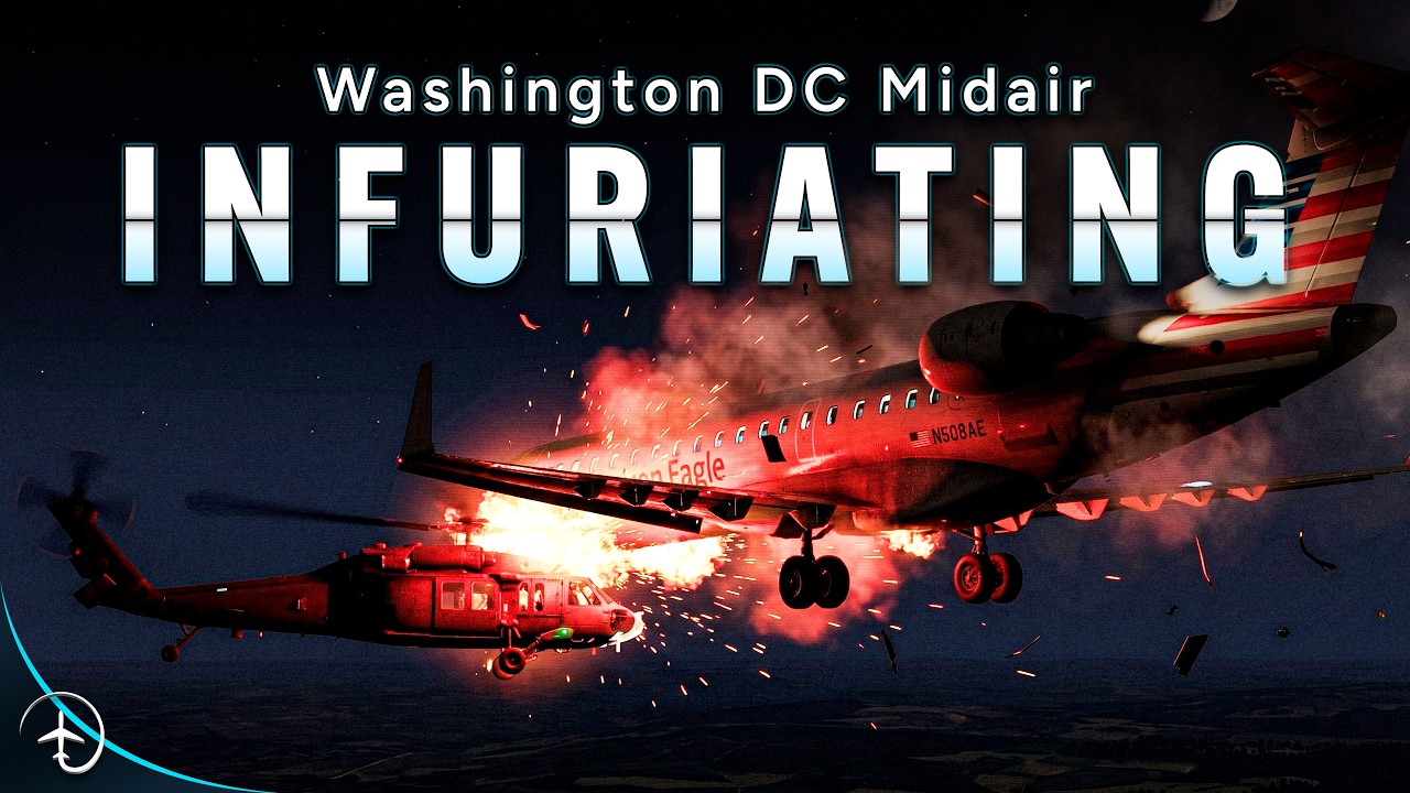
A military helicopter and a regional airliner collided above the Potomac River on January 29, 2025, killing all 67 people aboard both aircraft and ending more than 15 years without a fatal commercial aviation accident in the United States. The collision was not a sudden, unforeseeable event — it was the product of compounding systemic failures that investigators would spend over a year untangling.
What makes this particularly significant is that the disaster occurred not in some remote or poorly equipped airspace, but at one of the most politically prominent airports in the country, where known risks had been repeatedly flagged and just as repeatedly ignored.
A Safer Collision-Avoidance System Has Been Ready Since 2018 — Regulators Have Yet to Require It
The CRJ700 involved in the Potomac collision was equipped with TCAS 2 version 7.0, a system that can warn pilots of conflicting traffic but cannot specify direction, trajectory, or provide visual movement vectors — leaving crews to scan their screens and interpret the threat themselves. A successor system, ACAS X, uses ADS-B data to deliver precise verbal warnings such as "target at 2 o'clock, 200 feet below, moving east" and has met minimum performance standards since 2018. Europe's aviation authority did not formally recognise it until March 2025, and no regulator has yet mandated the transition.
The gap between capability and requirement is a recurring theme in this accident. Had both aircraft carried ACAS X, the developing conflict would likely have been identified earlier and described with enough precision to prompt evasive action.
"When something expensive is not mandated, it likely won't happen."
Helicopter's Altimeters Under-Read by Up to 100 Feet, Placing It Silently in the Approach Path
The UH-60L helicopter involved in the collision carried barometric altimeters that systematically indicated a lower altitude than the aircraft actually occupied — a discrepancy of up to 80 feet under normal conditions, and up to 100 feet when external fuel tanks were fitted. The tanks altered the rotor downwash in a way that distorted static pressure readings, and critically, this erroneous altitude was simultaneously transmitted through the helicopter's transponder to air traffic control and to any TCAS-equipped aircraft in the vicinity. Maintenance checks, conducted with engines off, never detected the fault.
This meant the helicopter's crew, believing they were flying accurately at 200 feet, were in reality occupying the approach path of runway 33 — a position neither they nor the controllers could verify from available data.
DCA's Traffic Shifted to 99% Airline Operations by 2024, Compressing Safety Margins Without Adding Capacity
Between 1991 and 2024, total instrument flight operations at Washington National Airport rose only 4.4% — from roughly 285,000 to 298,000 annual movements. What changed dramatically was the composition: air carrier flights climbed from 61% of all traffic to nearly 99%, while general aviation and air taxi movements collapsed from more than 110,000 combined to fewer than 4,000. A peninsula airport with no room to expand was quietly absorbing a far more demanding traffic mix.
Because airliners concentrate on a single long runway and demand tighter sequencing than smaller aircraft, this compositional shift imposed operational pressures that raw movement totals entirely obscured — pressures the airport's infrastructure and staffing were never redesigned to handle.
Congress Added Slots at DCA Over Officials' Objections; Safety Reduction Request Was Withdrawn as 'Too Political'
Washington National has operated as a slot-controlled airport for decades, with Congress holding authority over movement limits. According to sources cited in the investigation, Congress repeatedly added slots despite formal protests from airport officials — a process investigators linked to legislators seeking direct flight access for their home districts. Flight 5342 itself was likely one such addition, reportedly introduced after lobbying by Kansas representatives in 2023 or 2024. When the Potomac TRACON facility formally requested a reduction in permitted flights in 2023, district management instructed them to withdraw the request because it was, in their own words, "too political."
This institutional suppression of safety concerns sits at the heart of the NTSB's systemic findings. The collision did not occur because the hazard was unknown — it occurred because the mechanisms that should have acted on that knowledge had been neutralised.
"They had then been told by district management that they should withdraw that request because it was too political."
Helicopter Route 4 Offered Only 75 Feet of Vertical Separation from the Runway 33 Approach Path
To manage the dense helicopter traffic operating around Washington D.C. — serving the Pentagon, the White House, emergency services, and military VIP transport — corridor routes were established along the Potomac River using visual landmarks as reference points. Route 4, the corridor relevant to this accident, required helicopters to descend to a maximum of 200 feet. At the point where the route passed closest to the shoreline, that ceiling provided just 75 feet of vertical clearance from the three-degree instrument approach path into runway 33 at DCA. Further from the shore, that margin shrank further still. The routes were not created by the FAA but adopted from military corridors, and their intersection with active approach paths was never subjected to rigorous independent safety assessment.
Seventy-five feet of vertical separation — equivalent to roughly a seven-storey building — was all that stood between compliant helicopter operations and a catastrophic conflict with landing airliners.
Over 4,000 Aircraft-Helicopter Proximity Events Recorded at DCA Between 2018 and 2025; Warnings Were Not Acted On
Between January 2018 and February 2025, more than 4,000 instances were recorded in which a fixed-wing aircraft came within 1,000 feet of a helicopter in the DCA area. In 348 of those cases, the aircraft closed to within 500 feet — a rate exceeding five incidents per month. A near-collision in 2013 had already prompted a DCA tower helicopter working group to recommend moving Route 4 away from the runway 33 approach path; that recommendation produced no change. The FAA and the military both failed to classify the recurring proximity events as a serious safety issue, a failure investigators attributed to deficiencies in both organisations' safety management systems. The military's position, as reconstructed by the investigation team, was that the routes served national security requirements and therefore took precedence over civil air traffic concerns.
This was not a latent hazard waiting to be discovered — it was a documented, recurring, and formally reported threat that the institutions responsible for acting on it declined to address.
Single Controller Managed 12 Aircraft in Final 90 Seconds Before Collision, With No Documented Oversight Standard
At the time the two aircraft converged, a single local controller at DCA was handling both helicopter traffic and IFR arrivals in a combined position — a role that saw him transmitting at a rate of 7.7 times per minute. In the 90 seconds before the collision, his active traffic count reached 12 aircraft. The decision to keep the two control functions combined rested with an operations supervisor who had been at his post for approximately two hours without a documented break requirement — a gap that had no equivalent in the rules governing the controllers themselves. The supervisor did not identify the increasing complexity as a threshold requiring the positions to be split.
What procedure required was active workload monitoring and a clear, documented decision process for splitting combined positions. What existed instead was informal judgment, applied by a supervisor whose own alertness had no formal protection.
Radio Interference Stripped the Word 'Circling' From a Critical ATC Warning to the Helicopter Crew
As PAT 25 reached its 200-foot transition altitude and entered Route 4, the local controller transmitted a traffic advisory identifying a CRJ at 1,200 feet circling for runway 33. The word "circling" — the detail that would have directed the instructor pilot to scan a different part of the sky from the other aircraft queuing to land — was never received clearly aboard the helicopter and does not appear on the cockpit voice recorder. The instructor pilot, hearing only a partial message, almost certainly misidentified a different approaching aircraft as the threat and reported traffic in sight, immediately requesting visual separation. The controller approved it. At the moment that approval was given, the helicopter was approximately six and a half nautical miles from Flight 5342 — which was one of five aircraft approaching from the south.
Army Pilots Routinely Declared Traffic in Sight Before Confirming It, Testimony Reveals
After PAT 25 reported traffic in sight and received visual separation approval, the local controller — now managing multiple additional aircraft including an American Airlines flight joining final on runway 01 — moved on from monitoring the helicopter, operating on the assumption that its crew had Flight 5342 clearly identified. Testimony from other Army helicopter pilots gathered during the investigation established that calling "traffic in sight" before actually locating the conflicting aircraft had become normalised practice at DCA, used to maintain traffic flow because crews anticipated where the traffic would be. Inside the helicopter, the instructor pilot's attention was primarily directed at coaching the pilot flying through gusty, turbulent conditions; crabbing into a right-side crosswind simultaneously rotated the nose away from the CRJ's approach path, further reducing the likelihood of visual acquisition.
This was not a single failure — it was a chain of events in which a normalised unsafe practice, reduced controller monitoring, and adverse flight conditions all converged at the same moment.
"He's got them stacked up tonight."
Blocked Radio Transmission, Inhibited TCAS, and Altimeter Error Sealed the Collision's Final Seconds
At 20:47:33, a conflict alert sounded in the DCA tower as PAT 25 and Flight 5342 closed on each other. The controller transmitted an instruction to "pass behind the CRJ," but a simultaneous transmission from inside the helicopter blocked the critical phrase; the crew heard only "Pat CRJ." Inside the CRJ's cockpit, a TCAS traffic warning had activated — but the system's resolution advisory function is inhibited below 900 feet above ground, and neither pilot mentioned the alert on the cockpit voice recorder, suggesting they attributed it to the known holding helicopter rather than an immediate threat. The altimeter under-reading, meanwhile, was placing the helicopter directly in the approach path while its crew believed they were safely below it. Five seconds after the helicopter's rotor reached an indicated 278 feet, the CRJ's flight data recorder captured a 24-degree elevator deflection in under one second — the moment its crew finally saw what was directly ahead. It was too late. At 20:48, the helicopter's main rotor blades struck the CRJ's lower fuselage and left wing, and both aircraft were lost within four seconds.
The investigation would later reveal that no single intervention failed in isolation: the conflict alert was too familiar to command urgency, the safety system was neutralised by altitude, the altimeter transmitted false data, and the one instruction that might have separated the aircraft was erased by a blocked frequency.
NTSB Blames FAA for Placing Helicopter Route Near Active Approach Path and Ignoring Known Collision Risk
The NTSB's final report — 419 pages, 74 findings, and 57 recommendations, produced in just over a year — identified the probable cause as the FAA's decision to permit a helicopter route in close proximity to an active instrument approach path, combined with an institutional failure to regulate, review, or mitigate the documented risk of mid-air collisions in the area. Among the 57 recommendations, the most immediate was the abolition of helicopter Route 4. The report also identified the reliance on visual separation in complex, high-traffic night environments as categorically inadequate, called for mandatory implementation of ACAS X, and found that Washington National had been allowed to grow beyond its safe operational capacity under political pressure — with safety objections suppressed rather than resolved.
The NTSB's conclusions are a systemic indictment, not a verdict on individual error. Functioning safety management systems within the FAA, the military, and Congress, the report implies, should have intercepted this trajectory years before Flight 5342 began its final approach.
▶ Watch this segment — 1:00:41
Summarised from Mentour Pilot · 1:04:32. All credit belongs to the original creators. Streamed.News summarises publicly available video content.